Wednesday, December 18, 2013

What is surface hoar?

You may have heard us warning backcountry skiers and riders about buried surface hoar in our avalanche advisories this month.  So what is this lurking predator and how do we know where to find it? 

                Surface hoar, sometimes called “hoar frost”, is that beautiful, glimmering, feathery crystal you’ve probably admired while strolling around town.  When it gets buried on a steep slope, it can be an incredibly fragile and dangerous weak layer that can persist for weeks or months.  Surface hoar is the winter version of dew.  In order for it to form, we need 3 ingredients:  clear nighttime skies without canopy cover, calm winds, and some relative humidity in the air.  Of course, these feathery crystals aren’t a problem unless they are preserved below a slab of snow.  In Crested Butte, we frequently see strong winds prior to the arrival of the next storm, which helps destroy those fragile layers.  Sun-baked slopes can also cook the layer into submission.  The take-home point here is that there are a lot of factors at play that can make for variable and spotty distribution of buried surface hoar; some slopes may have it while others don’t.

                We had a significant surface hoar event around Thanksgiving that was buried on some slopes after our early December storms.  We’ve been finding it preserved on shaded and wind protected or leeward slopes, especially at lower elevations.  It has been the culprit for a handful of avalanches these past few weeks.  This layer has been fairly easy to identify in a snow pit: it looks like a thin grey stripe in the snow (this is not always the case). 

The obvious grey stripe in the middle of the pit is a layer of buried surface hoar found on Schuykill Ridge this week.
We are just exiting another high pressure weather pattern that is favorable for surface hoar growth.  When you’re out touring in avalanche terrain, look for surface hoar and what slopes it is forming on to give you a better idea of places to avoid if it gets buried and becomes problematic.  And don’t forget check our website for the most up-to-date avalanche conditions before you head out.  www.cbavalanchecenter.org

-Zach Guy

Monday, December 9, 2013

Sunday, December 8, 2013

No Niño??

For the past several years, much of the early season buzz about whether we were going to have a killer winter or a dud revolved (over. and over. and over...) about the pros and cons of an El Niño or La Niña   atmospheric and oceanic signal.  

Here is a post from one of my former meteorology professors at the University of Utah and total powder junkie himself, Jim Steenburgh.  He runs a great weather blog that discusses meteorology mostly around Utah, but a ton of his material is applicable to our locale as well.  Bookmark it and check it out! Infer what you can about how the lack of ENSO will affect our weather patterns...the overarching theme being....your guess is as good as mine.  A good perspective if nothing else.

http://wasatchweatherweenies.blogspot.com/2013/08/outlook-for-20132014-ski-season.html

My take is that the Arctic Oscillation is just as big of a contributing factor that is often over looked. "The positive phase of the Arctic Oscillation brings ocean storms farther north, making the weather wetter in Alaska, Scotland, and Scandinavia and drier in the western United States and the Mediterranean. In the negative phase of the Arctic Oscillation the patterns are reversed. A strongly negative phase of the Arctic Oscillation brings warm weather to high latitudes, and cold, stormy weather to the more temperate regions where people live. Over most of the past century, the Arctic Oscillation alternated between its positive and negative phase. For a period during the 1970s to mid-1990s, the Arctic Oscillation tended to stay in its positive phase. However, since then it has again alternated between positive and negative, with a record negative phase in the winter of 2009-2010"(National Snow and Ice Data Center).


What tilt are we in now you may ask??


These are very interesting (and confusing) but if you look at each graph, you have a neutral AO signal at zero, with the blue bars going up meaning positive, going down, negative. Makes you think a little what phase we have been in for extreme weather, like our early season snows, the Front Range floods in September, etc.

More info here:


I will probably steer some of my posts of this forecaster's blog to Jim's blog occasionally.  Enjoy this snowy Sunday...so far I like No Niño...

-Ian Havlick

Saturday, December 7, 2013

TED Talk on Avalanche Hazard and Risk

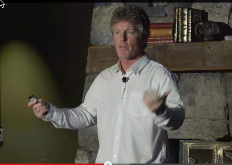
Grant Statham gave a great TED talk recently on risk in avalanche terrain that has been circulating around the avalanche community lately.  Grant has spent a lifetime climbing, skiing and guiding in extreme terrain around the world and he has spent the past 10 years or so working as a risk management specialist for Parks Canada.  Grant does a great job of explaining risk and hazard and how it relates to travel in avalanche terrain in this TED talk.

See Grant's 12 minute talk by clicking HERE or on Grant's photo below.


Grant Statham from Parks Canada

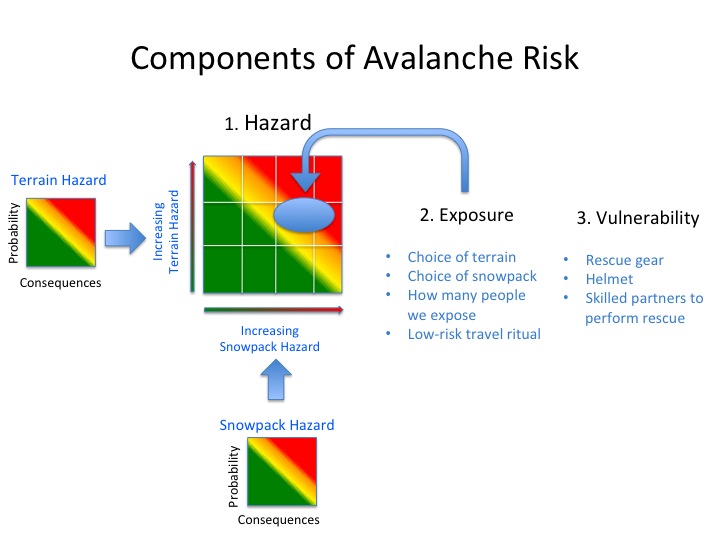
The components of avalanche risk from Bruce Tremper's (Utah Avalanche Center Director) new book Avalanche Essentials, which illustrate the points Grant makes in his talk.


-Ian Havlick
CBAC Forecaster


Thursday, April 11, 2013

Spring Skiing and Wet Slabs

-->
Spring is a great time to get into the backcountry and enjoy the expansive mountain ranges surrounding town.  You can safely pass through steep, avalanche terrain on most days, but there are still a few hazards that need to be on your radar, one of which is wet slabs. 
Presently, our high peaks either have a dry, winter snowpack (on north aspects), or are in some transitional stage as you move towards southerly aspects.   Many of these slopes have weak layers at the bottom of the snowpack that formed early this winter.   As the days get warmer and the sun angle gets higher, meltwater at the surface begins to percolate through the dry snow. We call this the “wetting front.”  As water moves through the snow, it changes the snow’s properties, causing it to weaken.  When it refreezes at night, frozen ice bonds form which make for a very strong and very stable snowpack.  When the wetting front advances to a weak layer, that layer can lose all of its strength and fail, resulting in a huge, wet slab avalanche. These are one of the most destructive types of avalanches we see.
Every winter we have weak layers near the ground, and every spring meltwater percolates through them.  Yet in most years, we only see a handful of wet slabs.  These are very hard to predict on a slope by slope basis, but you can eliminate your risk with a few spring skiing/riding practices. 
(1) Wet slabs are most common after several consecutive nights without a good refreeze.  Avoid avalanche terrain if it didn’t refreeze well overnight.  Clear, cold nights make for a good refreeze; cloudy, warm nights leave a poor refreeze.  Look at mountain temperature sensors (found at http://www.cbavalanchecenter.org/page.cfm?pageid=12570) and note the cloud cover before you leave home.  When you’re on slope, you can dig or probe to feel how thick that frozen block of snow is. On your hike up, if you are breaking through to your waist in wet grains, that’s a bad sign. 
(2) Wet slabs are most common during rapid or unusual warm-ups.  Plan to get off of slopes early in the day, when it is an inch of nice corn skiing rather than 8” of sloppy slush skiing.  This often means starting your hike before sunrise.  If you got a late start, go towards slopes that get sun later in the day, such as west or north aspects, rather than east or south aspects.  With your descent, anticipate that slopes lower in elevation or more easterly in aspect warmed up quicker; you might have to ski some frozen crust up high to play it safe down low.  Don’t go skiing if it is raining (duh).  If weather forecasters are talking about record high temperatures, go biking or drink beer on your deck. 
Thanks from the CBAC for another great season! We couldn’t do it without your support and observations.  Have a fun and safe spring ski season. 

-Zach Guy
*)
(*
*)
(*

Wednesday, February 13, 2013

When do Persistent Slabs go away?

Steve Banks
Executive Director
CBAC


You may have noticed that the Crested Butte Avalanche Center’s daily bulletin has been talking about the persistent slab problem for most of the winter now. We have also had some other avalanche problems such as storm slabs, wind slabs and even wet loose avalanche problems. These problems seem to come and go, while persistent slabs stay in the bulletin day after day. So when will the persistent slabs go away?

Persistent slabs is the name we give to the avalanche problem when we have a weak layer that is made up of faceted snow grains, depth hoar or surface hoar with a thick denser layer above. These types of weak snow grains tend to change very slowly and often linger throughout the entire winter season. Really it is a persistent weak layer that is the problem, but since it is the slab that could potentially kill you, we call it a persistent slab avalanche problem. These particular weak layers need a lot of time to morph into a better type of snow grain, and often we get into full on spring corn cycles before these layers begin to look any better.

So it would seem that if persistent slabs are really a problem, we must be triggering a lot of avalanches, right? Well, not really. These weak layers can have a certain amount of strength to them. The trick is to be able to recognize where and when they are strong enough to support the overlying snow as well as the additional weight of a backcountry rider. This is why we perform snowpack test like compression test and extended column tests. We are trying to determine how strong the weak layers may or may not be. Given the idea that stronger layers over weaker layers in the snowpack create avalanches, merely looking at the structure of the snowpack would indicate dangerous conditions. However snowpack tests are beginning to show harder results leading us to believe that the snowpack is gaining strength.

Now comes the tricky part. If the weak layers creating the persistent slab avalanche problem are becoming stronger, how do we know where and when they are strong enough to trust? It is always difficult to assess where an avalanche will occur, but it is especially difficult during times of relatively benign weather. This is when forecasters will be talking about low likely hood and high consequences avalanches. While it is difficult to initiate the slide, the resulting failure could entrain a lot of snow and have a life threatening outcome. So where would you be more likely to trigger an avalanche? The best way to know the answer is to dig in to the snow to check out the layering and perform some tests to see just how strong the slab is and just how weak the weak layers are.  In general we have a weaker snowpack closer to the town of CB where the snowpack is shallower. Stronger snowpacks can be found deeper in the mountains where the snowpack is deeper. When in doubt, err on the side of caution, and always remember to check the current avalanche bulletin at www.cbavalanchecenter.org.

Tuesday, February 5, 2013

Interpreting Snowpack Layers and Hardness


When the word avalanche is mentioned, images of curtains of snow cascading down the mountain come to mind. Specific conditions create avalanches. One of the basic elements, of course, is snow. The snowpack (the seasons snow on the ground) is a complex, but a key to understanding it is identifying layers and differences between them. Layers within the snowpack are a record of the winter’s weather. Like tree rings or strata of rock, layers can be traced to dates and conditions that formed them.

 One of the most important characteristics of a layer is its hardness. Harder snow is stronger and cohesive, while softer snow is weaker. For a slab avalanche we need a strong layer over a weak layer. We actually use a “Hand Hardness” scale by pushing our hand into each layer to determine the hardness. “Fist” hard snow is the softest, then “four finger”, then “one finger” snow being harder, and so on. No, there’s no “middle finger” on this scale. The greater the hardness difference of neighboring layers, the more likely we are to see avalanches at that interface.

The recent snowpack history from the Crested Butte backcountry is a great example of layer hardness relating to human triggered avalanches. Consider these three scenarios:

1) The last week in January brought up to 50” of snow over seven days. While this storm caused some natural avalanches, riders initially weren’t triggering many slab avalanches. Most of the snow came in light and soft. Digging in sheltered and shaded areas during the middle of the storm, you’d find very soft (fist hard) new snow on top of some slightly harder old snow.

2) The storm ended on Thursday January 31st. By then the wind had formed stiff slabs at all elevations but especially near and above treeline. Digging on some leeward slopes near treeline you could find one finger hard wind-loaded snow sitting over four finger hard facets. Many reports of natural and skier triggered slides came in from wind-loaded areas.

3) By Monday, February 4th, the storm had ended four days prior. Mild daytime temperatures had created settlement in the height of the storm snow and an increase in its hardness. I was skiing on sheltered easterly aspects below treeline.  These slopes had seen very little wind in the past week. Throughout the day, we felt many rumbling collapses and we remotely triggered two sizable avalanches. On these sheltered slopes we found storm snow that had stiffened to a hardness of four finger sitting over fist hard facets.

This storm and avalanche cycle in the late January to early February shows how layer hardness often relates to skier triggering. The most consistent skier-triggering occurred where we found the most change in hardness in adjacent strong over weak layer. If this talk of layers seems daunting, remember that you don’t have to figure it out on your own. The daily avalanche forecast is best place for current conditions. You can check out the "Observations" page to read what other backcountry travelers are seeing. You could even look at the "Snow Profiles" page for technical graphs of recent snow pits. From there you can investigate the snow as much or as little as you want. But most of all have fun in the mountains, make sound decisions, and stay safe doing it. Check out the daily forecast at www.cbavalanchecenter.org

CBAC Forecaster Josh Hirshberg

Monday, February 4, 2013

Some Crusty Thoughts


South facing slopes were the go-to for many folks in town to find stable skiing and riding during our December storm cycle. The snow fell on dirt on many low elevation sunny slopes, rather than the problematic facets that were lurking on shaded slopes. Someone asked me recently, “When do south aspects become dangerous?” It depends, of course, but a lot of it has to do with crusts. With all the sun we’ve been getting in January, we’ve seen melt-freeze crusts form on most of our southerly slopes. So what does this mean for future stability and what happens when snow piles on above crusts?

There are a lot of variables at play, so I’ll illustrate with a few examples. The best case scenario is that we have a thick, stout crust that is still warm as a new storm arrives, and the new snow falls warm and wet. Instabilities at this crust/new snow interface will be short-lived because a good bond will form. This pattern is more often played out in the springtime, which is why we can sometimes find stable powder skiing after a spring storm drops snow on widespread crusty surfaces.

The worst case scenario is if we have facets form and stay preserved above a crust prior to a big snowfall. This can happen in a number of ways. Mid-winter, we will occasionally see crusts form on days when it is still pretty cold, but there is strong enough solar radiation to warm and melt the snow just below the surface. The actual surface of the snow stays cool because it radiates heat, so what we have is a thin crust forming below cold faceting snow at the surface. Suddenly we have a bed surface with a weak layer waiting for a slab to ruin someone’s day. A similar scenario is if we have a crust that has been forming for days or weeks, and then we get a dusting of snow on top followed by clear and cold weather. This gives us another scary bed surface with facets developing above it. Often these facets above crusts are difficult to spot with the naked eye after they are buried by a slab, but a stability test will usually give them away.

Now here’s the really tricky part. When a crust gets buried, it can have unusual behavior. Crusts act as vapor barriers to the normal, everyday movement of water vapor through the snowpack (Picture TSA security clogging the flow of people at an airport). This can lead to faceting above or below the crust, even if the bonds were originally strong. This type of problem is most common in cold, shallow snowpacks such as what we have in Crested Butte right now. We have already observed pronounced facets developing under our current crusts on south aspects. With a big enough load, that crust won’t be able to support the weight above it and the whole thing will come crashing down, failing on those facets below the crust.

So if I’ve lost you with all this technical jibber jabber, here’s the bottom line. Crusts have the potential to be a dangerous interface as more snow piles above them. Treat a buried crust as guilty until proven innocent. Watch for signs of instability and dig down to check how the snow is bonding to that crust before committing to steep terrain. And remember that south facing slopes that you were skiing or riding safely back in December may no longer be stable if we get another big storm cycle. For daily avalanche advisories and observations, visit cbavalanchecenter.org

CBAC Forecaster Zach Guy


Tuesday, January 15, 2013

Tech Tip: Did Your Compression Test Just POP or DROP?


Recent research in the snow and avalanche world is showing that how a compression test fails is just as or more important than the number of taps it takes for it to fail. Researchers have come up with a classification system to qualify and describe fractures in snowpack tests. This system is known as Fracture Character. Fracture Character does not necessarily replace Shear Quality—or the “Q scale.” It compliments it, and can even provide a bit more information about the relationship of the weak layer and the overlying slab. It breaks fracture type into 2 main categories—sudden fractures and non sudden fractures. This post will solely deal with sudden fractures.

Sudden fractures are what avalanche practitioners call “pops” and “drops” in snowpack tests. If the fracture is a pop, a thin crack will cross the column of snow with one loading step (or tap) and the block will slide off the weak layer easily. It could be your 5th tap or your 20th—the key is that one tap initiates a crack that crosses the entire snowpack column. This may not be as obvious as the old analogy of “it shot out like a cash register drawer.” On lower angle slopes you may have to grab the block and give it a slight tug. If it slides off without much effort you are still dealing with a pop. If it is a drop there will be an observable (and sometimes audible) collapse on the weak layer that occurs with one loading step, or tap. If you flip over the block it may not necessarily be smooth. Drops in depth hoar will commonly look rough when you examine the fracture.

Why is this important? Researchers have correlated sudden fractures with skier triggering avalanches. Recent studies have shown that “Fracture Character is a valuable addition to the compression test score since most failure layers of slab avalanches produce sudden fractures in compression tests” (van Herwijnen and Jamieson 2004a). Paying attention to whether your compression test “pops” or “drops” can give you a better indication of whether or not a specific slope has the potential to avalanche. This is also great information to include when you send in your observations to the CBAC.

Remember that performing snowpack tests is just one part assessing the snowpack.  No one test can tell you if a slope is stable. If you want more information on this topic check out Alec van Herwijnen and Bruce Jamieson’s 2004 paper titled Fracture Character in Compression Tests. The chart below compares Fracture Character with shear quality and provides definitions for Fracture Character. 

John MacKinnon


Works Cited
Birkland, Karl "Comments on Using Shear Quality and Fracture Character
to Improve Stability Test Interpretation." TAR Vol. 23. No. 2: 2004.

van Herwijnen and Jamieson 2003. An update on fracture character in stability tests. Avalanche
News
66. Canadian Avalanche Association, Revelstoke, BC, 26-28.
van Herwijnen and Jamieson 2004. Fracture Character in Compression Tests. ISSW 2004.
van Herwijnen and Jamieson 2004a. Fracture Character in Compression Tests." ISSW 2004.